
Delwedd:Netzarim junction map.png
Maint y rhagolwg: 557 × 599 picsel. Eglurdebau eraill: 223 × 240 picsel | 446 × 480 picsel | 674 × 725 picsel.
Maint llawn ((674 × 725 picsel, maint y ffeil: 82 KB, ffurf MIME: image/png))
Crynodeb

|
This locator map image could be re-created using vector graphics as an SVG file. This has several advantages; see Commons:Media for cleanup for more information. If an SVG form of this image is available, please upload it and afterwards replace this template with
{{vector version available|new image name}}.
It is recommended to name the SVG file “Netzarim junction map.svg”—then the template Vector version available (or Vva) does not need the new image name parameter. |
| Disgrifiad |
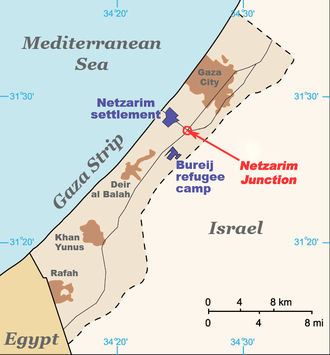
English: Map of the Gaza Strip indicating the locations of Bureij refugee camp, the former Netzarim settlement and the Netzarim Junction. Based on :Image:Gaza Strip map blank.svg. |
| Dyddiad | |
| Ffynhonnell | Gwaith yr uwchlwythwr (Original text: I created this work entirely by myself.) |
| Awdur | ChrisO (talk) |
Trwyddedu
Mae Vanished user 03 at Saesneg Wicipedia, deiliad yr hawlfraint ar y gwaith hwn, yn ei gyhoeddi yn ôl termau'r drwydded a ganlyn:
Trwyddedir y ffeil hon yn ôl termau'r drwydded Creative Commons Attribution-Share Alike 3.0 Unported.
Cydnabyddiaeth: Vanished user 03 at Saesneg Wicipedia
- Mae'n rhydd i chi:
- rhannu – gallwch gopïo, dosbarthu a throsglwyddo'r gwaith
- ailwampio – gallwch addasu'r gwaith
- Ar yr amodau canlynol:
- cydnabyddiaeth – Mae'n rhaid i chi nodi manylion y gwaith hwn, rhoi dolen i'r drwydded, a nodi os y bu golygu arni, yn y modd a benwyd gan yr awdur neu'r trwyddedwr (ond heb awgrymu o gwbl eu bod yn eich cymeradwyo chi na'ch defnydd o'r gwaith).
- rhannu ar dermau tebyg – Os byddwch yn addasu'r gwaith hwn, neu yn ei drawsnewid, neu yn adeiladu arno, mae'n rhaid i chi ddosbarthu'r gwaith dan drwydded sy'n union yr un fath same a'r gwreiddiol.
Cofnod lòg yr uwchlwythiad gwreiddiol
Transferred from en.wikipedia to Commons by Magnus Manske using CommonsHelper.
The original description page was here. All following user names refer to en.wikipedia.
- 2009-04-06 19:56 Jaakobou 674×725× (84061 bytes) Update by adding a marking and fixing colors to emphasize the junction where the al-Durrah event occurred.
- 2008-07-18 18:52 Vanished user 03 674×725× (28831 bytes) {{Information |Description=Map of the Gaza Strip indicating the locations of Bureij refugee camp, the former Netzarim settlement and the Netzarim Junction. Based on [[:Image:Gaza Strip map blank.svg]]. |Source=I created this work entirely by myself. |Date
Hanes y ffeil
Cliciwch ar ddyddiad / amser i weld y ffeil fel ag yr oedd bryd hynny.
| Dyddiad / Amser | Bawdlun | Hyd a lled | Defnyddiwr | Sylw | |
|---|---|---|---|---|---|
| cyfredol | 16:08, 19 Chwefror 2011 | | 674 × 725 (82 KB) | File Upload Bot (Magnus Manske) | {{BotMoveToCommons|en.wikipedia|year={{subst:CURRENTYEAR}}|month={{subst:CURRENTMONTHNAME}}|day={{subst:CURRENTDAY}}}} {{Information |Description={{en|Map of the Gaza Strip indicating the locations of Bureij refugee camp, the former Netzarim settlement a |
Cysylltiadau'r ffeil
Mae'r 1 tudalennau a ddefnyddir isod yn cysylltu i'r ddelwedd hon:
Defnydd cydwici y ffeil
Mae'r wicis eraill hyn yn defnyddio'r ffeil hon:
- Y defnydd ar en.wikipedia.org
- Y defnydd ar es.wikipedia.org
- Y defnydd ar he.wikipedia.org
- Y defnydd ar id.wikipedia.org
- Y defnydd ar pnb.wikipedia.org
- Y defnydd ar ru.wikipedia.org
- Y defnydd ar uk.wikipedia.org
- Y defnydd ar ur.wikipedia.org
- Y defnydd ar uz.wikipedia.org
- Y defnydd ar vi.wikipedia.org
- Y defnydd ar zh.wikipedia.org